Maps of Berlin
Jump to navigation
Jump to search
Deutsch: Diese Bildergalerie zeigt die verschiedensten Karten des Landes und der Stadt Berlin und seiner Bezirke.
English: This gallery of pictures shows the maps of the state and the city Berlin (Germany) and the boroughs of Berlin.
alte Karten - old maps
[edit]-
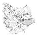
 Klöden-Plan, Berlin und Cölln ca. 1230
 -
 Berlin und Cölln im Anfang des 13. Jahrhunderts
 -
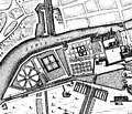
 Berlin 1652 von Johann Gregor Memhardt
 -
 cut with the Lust- and Schlossgarten
 -
 map of Tiergarten by Memhardt, 1656
 -
 Berlin Map from 1688
 -
 Plan von Berlin 1710
 -
 1730, by Werner
 -
 Plan der königlichen Residenzstadt Berlin 1737
 -
 Map of the "Königlich Preußische Residenz Berlin" made by Schleuen around 1740
 -
 Grundriß der Königlichen Residenzstädte Berlin 1789
 -
 Grundriß der Königlichen Residenzstädte um 1800
 -
 1865 Hobrecht map, northeast of Berlin
 -
 Map for the maneuver of the "Garde-Corps" in autumn 1842
 -
 Floor plan of Berlin 1846
 -
 September 1884
 -
 1855
1855 -
 1860, steel engraving
 -
 1885, steel engraving
 -
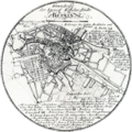
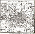
 Umgebung von Berlin 1888 (aus Meyers Konversationslexikon)
 -
 Berlin 1888 (aus Meyers Konversationslexikon)
 -
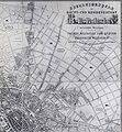
 Map made bei Straube, 1908
 -
 Map at the beginning of the 20th century
 -
 floor in the southwest suburbs of Berlin
 -
 Alte Karte von 1885 mit Regierungsviertel


.jpg)


-
 Friedrichshain
 -
 Museumsinsel
 -
 Hohenlohe-Straße


Karten von Berlin - maps of Berlin
[edit]-
 Germany, Länder: Berlin
 -
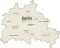
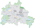
 Map of Berlin with the new boroughs and their localities
 -
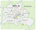
 Karte von Berlin einschließlich Bezirksgrenzen und Gewässern
 -
 Übersichtsplan
 -
 Landnutzungskarte
 -
 Schwarzplan
 -
 Schwarzplan von Berlin
 -
 Administrative Grenzen, Gewässer, Bebauung und Grünflächen
 -
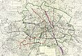
 ÖPNV-Karte
 -
 Berliner Bezirke seit 2001
 -
 Berliner Bezirke bis 2001
 -
 Berlin und seine Bezirke
 -
 Berliner Bezirke nach der Bezirksreform 2002
 -
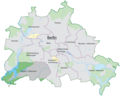
 Berlin Map with the boundaries of its 12 boroughs
 -
 Germany after WWII, Berlin zones: France
 -
 Germany after WWII, Berlin zones: UK
 -
 Germany after WWII, Berlin zones: USA
 -
 Germany divided, Berlin West: districts
 -
 Germany divided, Berlin West: districts, with names
 -
 Germany after WWII, Berlin zones: USSR
 -
 Germany divided, Berlin East: districts, with names
 -
 map showing sectors of occupation of berlin
 -
 Berlin satellite image with Berlin wall
 -
 Straßenplan von Berlin


.svg)


Karten der Bezirke - maps of boroughs
[edit]Charlottenburg-Wilmersdorf
[edit]-
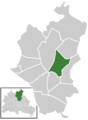
 Die Ortsteile im Bezirk Charlottenburg-Wilmersdorf von Berlin
 -
 Charlottenburg im Bezirk Charlottenburg-Wilmersdorf von Berlin
 -
 Charlottenburg-Nord im Bezirk Charlottenburg-Wilmersdorf von Berlin
 -
 Grunewald im Bezirk Charlottenburg-Wilmersdorf von Berlin
 -
 Halensee im Bezirk Charlottenburg-Wilmersdorf von Berlin
 -
 Schmargendorf im Bezirk Charlottenburg-Wilmersdorf von Berlin
 -
 Westend im Bezirk Charlottenburg-Wilmersdorf von Berlin
 -
 Wilmersdorf im Bezirk Charlottenburg-Wilmersdorf von Berlin


Friedrichshain-Kreuzberg
[edit]-
 Die Ortsteile im Bezirk Friedrichshain-Kreuzberg von Berlin
 -
 Friedrichshain im Bezirk Friedrichshain-Kreuzberg von Berlin
 -
 Kreuzberg im Bezirk Friedrichshain-Kreuzberg von Berlin


Lichtenberg
[edit]-
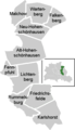 Die Ortsteile im Bezirk Lichtenberg von Berlin
 -
 Alt-Hohenschönhausen im Bezirk Lichtenberg von Berlin
 -
 Falkenberg im Bezirk Lichtenberg von Berlin
 -
 Fennpfuhl im Bezirk Lichtenberg von Berlin
 -
 Friedrichsfelde im Bezirk Lichtenberg von Berlin
 -
 Karlshorst im Bezirk Lichtenberg von Berlin
 -
 Lichtenberg im Bezirk Lichtenberg von Berlin
 -
 Malchow im Bezirk Lichtenberg von Berlin
 -
 Neu-Hohenschönhausen im Bezirk Lichtenberg von Berlin
 -
 Rummelsburg im Bezirk Lichtenberg von Berlin
 -
 Wartenberg im Bezirk Lichtenberg von Berlin


Marzahn-Hellersdorf
[edit]-
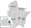 Die Ortsteile im Bezirk Marzahn-Hellersdorf von Berlin
 -
 Biesdorf im Bezirk Marzahn-Hellersdorf von Berlin
 -
 Hellersdorf im Bezirk Marzahn-Hellersdorf von Berlin
 -
 Kaulsdorf im Bezirk Mitte Marzahn-Hellersdorf Berlin
 -
 Mahlsdorf im Bezirk Mitte Marzahn-Hellersdorf Berlin
 -
 Marzahn im Bezirk Mitte Marzahn-Hellersdorf Berlin


Mitte
[edit]-
 Die Ortsteile im Bezirk Mitte von Berlin
 -
 Gesundbrunnen im Bezirk Mitte von Berlin
 -
 Hansaviertel im Bezirk Mitte von Berlin
 -
 Moabit im Bezirk Mitte von Berlin
 -
 Mitte im Bezirk Mitte von Berlin
 -
 Tiergarten im Bezirk Mitte von Berlin
 -
 Wedding im Bezirk Mitte von Berlin


Neukölln
[edit]-
 Die Ortsteile im Bezirk Neukölln von Berlin
 -
 Britz im Bezirk Neukölln von Berlin
 -
 Buckow im Bezirk Neukölln von Berlin
 -
 Gropiusstadt im Bezirk Neukölln von Berlin
 -
 Neukölln im Bezirk Neukölln von Berlin
 -
 Rudow im Bezirk Neukölln von Berlin


Pankow
[edit]-
 Die Ortsteile im Bezirk Pankow von Berlin
 -
 Blankenburg im Bezirk Pankow von Berlin
 -
 Blankenfelde im Bezirk Pankow von Berlin
 -
 Buch im Bezirk Pankow von Berlin
 -
 Französisch Buchholz im Bezirk Pankow von Berlin
 -
 Heinersdorf im Bezirk Pankow von Berlin
 -
 Karow im Bezirk Pankow von Berlin
 -
 Niederschönhausen im Bezirk Pankow von Berlin
 -
 Pankow im Bezirk Pankow von Berlin
 -
 Prenzlauer Berg im Bezirk Pankow von Berlin
 -
 Rosenthal im Bezirk Pankow von Berlin
 -
 Stadtrandsiedlung Malchow im Bezirk Pankow von Berlin
 -
 Weißensee im Bezirk Pankow von Berlin
 -
 Wilhelmsruh im Bezirk Pankow von Berlin


Reinickendorf
[edit]-
 Die Ortsteile im Bezirk Reinickendorf von Berlin
 -
 Frohnau im Bezirk Reinickendorf von Berlin
 -
 Heiligensee im Bezirk Reinickendorf von Berlin
 -
 Hermsdorf im Bezirk Reinickendorf von Berlin
 -
 Konradshöhe im Bezirk Reinickendorf von Berlin
 -
 Märkisches Viertel im Bezirk Reinickendorf von Berlin
 -
 Reinickendorf im Bezirk Reinickendorf von Berlin
 -
 Tegel im Bezirk Reinickendorf von Berlin
 -
 Waidmannslust im Bezirk Reinickendorf von Berlin
 -
 Wittenau im Bezirk Reinickendorf von Berlin


Spandau
[edit]-
 Die Ortsteile im Bezirk Spandau von Berlin
 -
 Falkenhagener Feld im Bezirk Spandau von Berlin
 -
 Gatow im Bezirk Spandau von Berlin
 -
 Hakenfelde im Bezirk Spandau von Berlin
 -
 Haselhorst im Bezirk Spandau von Berlin
 -
 Kladow im Bezirk Spandau von Berlin
 -
 Siemensstadt im Bezirk Spandau von Berlin
 -
 Spandau im Bezirk Spandau von Berlin
 -
 Staaken im Bezirk Spandau von Berlin
 -
 Wilhelmstadt im Bezirk Spandau von Berlin


Steglitz-Zehlendorf
[edit]-
 Die Ortsteile im Bezirk Steglitz-Zehlendorf von Berlin
 -
 Dahlem im Bezirk Steglitz-Zehlendorf von Berlin
 -
 Lankwitz im Bezirk Steglitz-Zehlendorf von Berlin
 -
 Lichterfelde im Bezirk Steglitz-Zehlendorf von Berlin
 -
 Nikolassee im Bezirk Steglitz-Zehlendorf von Berlin
 -
 Steglitz im Bezirk Steglitz-Zehlendorf von Berlin
 -
 Wannsee im Bezirk Steglitz-Zehlendorf von Berlin
 -
 Zehlendorf im Bezirk Steglitz-Zehlendorf von Berlin


Tempelhof-Schöneberg
[edit]-
 Die Ortsteile im Bezirk Tempelhof-Schöneberg von Berlin
 -
 Friedenau im Bezirk Tempelhof-Schöneberg von Berlin
 -
 Schöneberg im Bezirk Tempelhof-Schöneberg von Berlin
 -
 Tempelhof im Bezirk Tempelhof-Schöneberg von Berlin
 -
 Mariendorf im Bezirk Tempelhof-Schöneberg von Berlin
 -
 Marienfelde im Bezirk Tempelhof-Schöneberg von Berlin
 -
 Lichtenrade im Bezirk Tempelhof-Schöneberg von Berlin


Treptow-Köpenick
[edit]-
 Die Ortsteile im Bezirk Treptow-Köpenick von Berlin
 -
 Adlershof im Bezirk Treptow-Köpenick von Berlin
 -
 Altglienicke im Bezirk Treptow-Köpenick von Berlin
 -
 Alt-Treptow im Bezirk Treptow-Köpenick von Berlin
 -
 Baumschulenweg im Bezirk Treptow-Köpenick von Berlin
 -
 Bohnsdorf im Bezirk Treptow-Köpenick von Berlin
 -
 Friedrichshagen im Bezirk Treptow-Köpenick von Berlin
 -
 Grünau im Bezirk Treptow-Köpenick von Berlin
 -
 Johannisthal im Bezirk Treptow-Köpenick von Berlin
 -
 Köpenick im Bezirk Treptow-Köpenick von Berlin
 -
 Müggelheim im Bezirk Treptow-Köpenick von Berlin
 -
 Niederschöneweide im Bezirk Treptow-Köpenick von Berlin
 -
 Oberschöneweide im Bezirk Treptow-Köpenick von Berlin
 -
 Plänterwald im Bezirk Treptow-Köpenick von Berlin
 -
 Rahnsdrof im Bezirk Treptow-Köpenick von Berlin
 -
 Schmöckwitz im Bezirk Treptow-Köpenick von Berlin


Andere - other
[edit]-
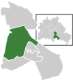
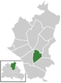
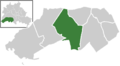
 Lage des Bezirks Charlottenburg-Wilmersdorf in Berlin
 -
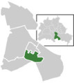
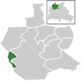
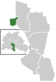
 Lage des Bezirks Friedrichshain-Kreuzberg in Berlin
 -
 Lage des Bezirks Lichtenberg in Berlin
 -
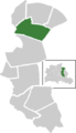
 Lage des Bezirks Marzahn-Hellersdorf in Berlin
 -
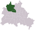
 Lage des Bezirks Mitte in Berlin
 -
 Lage des Bezirks Neukölln in Berlin
 -
 Lage des Bezirks Pankow in Berlin
 -
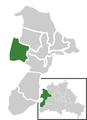
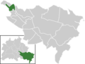
 Lage des Bezirks Reinickendorf in Berlin
 -
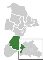
 Lage des Bezirks Spandau in Berlin
 -
 Lage des Bezirks Steglitz-Zehlendorf in Berlin
 -
 Lage des Bezirks Tempelhof-Schöneberg in Berlin
 -
 Lage des Bezirks Treptow-Köpenick in Berlin


Sonstiges - Miscellaneous
[edit]-
 Karte der Wissenschafts- und Mediastadt WISTA Berlin-Adlershof, 2007, auch alsSVG
 -
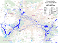 Karte der Berliner Wasserstraßen
 -
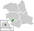
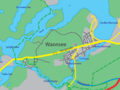 Karte von Berlin-Wannsee
 -
 Seengebiet im Südosten von Berlin
 -
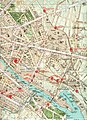
 Gebiet der historischen Friedrichstadt in Berlin
 -
 Standorte der Charité - Universitätsmedizin Berlin
 -
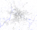
 population density, 2002
 -
 population movement, 2002
 -
 income situation, 2003
 -
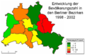 population history 1998-2002
 -
 accomation with daycares, 2003
 -
 Flughafen Berlin-Schönefeld Bestand und Neubau
 -
 Oberland- und Teilestraße


Parks
[edit]-
 Übersichtskarte Kreuzberg-Friedrichshain
 -
 Görlitzerpark
 -
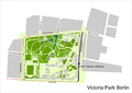 Viktoriapark
 -
 Böcklerpark
 -
 Ernst-Thälmann-Park


