Atlas of Iran

From Wikimedia Commons, the free media repository
(Redirected from Atlas of the Persian Empire)
Jump to navigation Jump to search
Wikimedia Commons Atlas of the World

The Wikimedia Atlas of the World is an organized and commented collection of geographical, political and historical maps available at Wikimedia Commons.
Discussion • Update the atlas • Index of the Atlas • Atlas in categories • Other atlases on line
The introductions of the country, dependency and region entries are in the native languages and in English. The other introductions are in English.
 
Atlas-country
Iran


ايران‎

فارسی [1]ايران‎ - جمهوری اسلامی ايران

ایران کشوری در جنوب غربی آسیا در منطقهٔ مشهور به خاورمیانه است. پایتخت آن تهران است.

Azərbaycan İran Qərbi-Asiyada dövlət. Şimalda Ermənistan, Azərbaycan və Türkmənistanla , şərqdə Əfqanıstan və Pakistanla, qərbdə İraq və Türkiyə ilə sərhəddir. Şimaldan Xəzər dənizi ilə, Cənubdan İran və Oman körfəzləri ilə əhatə olunmuşdur. Ərazi 31 ostana bölünmüşdür. Ostanlara rəhbərliyi Daxili İşlər naziri tərəfindən təyin edilən general-qubernatorlar edir. Ostanlar öz növbələrində şəhristanlara bölünürlər. Şəhristanların tərkibinə şəhərlər və digər ərazilər daxildirlər. Şəhristana rəhbərlik edən məmurlar bəzən təyin olunur bəzəndə seçilirlər.
Kurdî / كوردی Îran (farsî: جمهوری اسلامی ایران) welatekê Rojhilata Navîn e. Navê wê yê fermî Komara Îslamî ya Îranê ye (bi Farisî: Comhûrîyê Êslamîyê Îran). Îran li Bukur bi Ermenistanê, Azerbaycanê û Tirkmenistanê re, li rojava bi Tirkiye û Îraqê re, li rojhilat bi Efxanistan û Pakistanê re û li başûr bi Kendava Farisî û Kendava Omanê re û li aliyê din ê wan herduyan re bi Kuweyt , Erebistana Siûdî, Bahreyn, Qeter, Mîrnişînên Erebî yên Yekbûyî û Ommanê re hevsî e. Mezzhebê fermî yê Îranê Şî û zimanê fermî jî Farisî ye.
English Iran - Islamic Republic of Iran

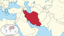
The Islamic Republic of Iran, formerly known as Persia in the West, is a large Western Asian country located in the Middle East and Central Asia. Its area equals the size of the United Kingdom, France, Spain, and Germany combined. Iran borders ► Armenia, ► Azerbaijan (including its ► Nakhichevan exclave) and ► Turkmenistan to the north, ► Afghanistan and ► Pakistan to the east, and ► Iraq (with ► Kurdistan) and ► Turkey to the west. In addition, it borders the Persian Gulf, across which lie ► Kuwait, ► Iraq, ► Saudi Arabia, ► Bahrain, ► Oman, ► Qatar, and the ► United Arab Emirates.


Short name  Iran
Official name Islamic Republic of Iran
Status Independent country, united since 1502
Location Middle East
Capital تهران (Tehran)
Population 79,926,270 inhabitants
Area 1,628,771 square kilometres (628,872 sq mi)
Major languages Persian (official), Azerbaijani, Kurdish
Major religions Shi'a Islam, Sunni Islam, Zoroastrianism
More information Iran, Geography of Iran, History of Iran and Politics of Iran
More images Iran - Iran (Category).

General maps

Map of Iran
Map of Iran in Persian
Map of Iran
Topographic map
Provinces of Iran
Counties of Iran

History maps

This section holds a short summary of the history of the area of present-day Iran (Persia), illustrated with maps, including historical maps of former countries and empires that included present-day Iran (Persia).

Fertile Crescent
Akkadian Empire around 2000 BCE
The Elamite Empire (2700-539 BCE)
The Assyrian Empire in the 9th to 7th centuries BC
Deportation of the Jews by the Assyrian Empire
Neo-Assyrian Empire
Urartu at its greatest extent in the time of Sarduris II, 743 BC
Median Empire

Persian Empire

The Persian Achaemenid Empire (not at its greatest extent)
The Persian Achaemenid Empire (at its greatest extent)
The Persian Achaemenid Empire (not at its greatest extent)

Macedonian Empire

334-323 BCE: Macedonian Empire - occupying country ► Macedonian Empire

Map of the Empire of Alexander 334-323 BCE
Hellenistic successor states:
 
Kingdom of Ptolemy
 
Kingdom of Cassander
 
Kingdom of Lysimachus
 
Kingdom of Seleucus
Other states:
 
Rome
Map of the diadochs kingdoms (in french)
Hellenistic world in 200 BCE
Greco-Bactrian kingdom (250-125 BCE)

Parthia

250 BCE-225 CE: Parthia (اشکانیان - Ashkâniân) - independent monarchy

The Parthian empire
The Parthian Empire (250 BCE-226 CE)
Map of Parthia 100 BC
Indo-Sassanide Empire
The Persian Sassanian Empire (226-650) in 602 to 629, Strokes: Under Sassanid military control.
Sassanide Empire
Sassanide Empire
Expansion of the Caliphate
Age of the Caliphs
Iran around 1000
The Seljuq Empire 1037-1194
The Khwarezmid Empire around 1220
Map showing changes in borders of the Mongol Empire from founding by Genghis Khan in 1206, Genghis Khan's death in 1227 to the rule of Kublai Khan (1260–1294). (Uses modern day borders)
 
Mongol Empire

By 1294 the empire had split into:

 
Empire of the Great Khan (Yuan Dynasty)
The Timurid Empire 1405
The Persian Safavid Empire (1501-1722/1736)
The Safavid Empire
Iran around 1900
Kurdish Republic of Mahabad and Autonomous Republic of Azerbaijan in 1945-1946

Old maps

This section holds copies of original general maps more than 70 years old.

The Median Empire (728-550 BCE)
The Achaemid Empire (Persia
The Expedition of Alexander the Great 334-323 BCE
Map of the Empire of Alexander
Map of the Empire of Alexander (Norwegian)
Caliphate around 750
The Timurid Empire 1405
Map of Persia around 1700
A 1753 map by Robert De Vaugondy titled ESTATS DU GRAND-SEIGNEUR EN ASIE where the color yellow marks the Greater Persian territores.
An 1808 British map of Persia.
Qajar Iran, 1886

Ethno-linguistic maps

Ethno-religious map of Iran by the CIA (2009)
Map of the persian inhabited areas in Iran and Afghanistan
Map of the Azerbaijani inhabited areas in Iran

Other maps

Major crops
Railways
Biotopes of Iran
Biotopes of Iran
Iran faultlines
International trade
Oil
Nuclear program
Oil and gas infrastructure, 2009
Strait of Hormuz, 2009
Energy prospects in the southern Caspian Sea, 2009

Satellite maps

Satellite map

Notes and references

General remarks:

  • The WIKIMEDIA COMMONS Atlas of the World is an organized and commented collection of geographical, political and historical maps available at Wikimedia Commons. The main page is therefore the portal to maps and cartography on Wikimedia. That page contains links to entries by country, continent and by topic as well as general notes and references.
  • Every entry has an introduction section in English. If other languages are native and/or official in an entity, introductions in other languages are added in separate sections. The text of the introduction(s) is based on the content of the Wikipedia encyclopedia. For sources of the introduction see therefore the Wikipedia entries linked to. The same goes for the texts in the history sections.
  • Historical maps are included in the continent, country and dependency entries.
  • The status of various entities is disputed. See the content for the entities concerned.
  • The maps of former countries that are more or less continued by a present-day country or had a territory included in only one or two countries are included in the atlas of the present-day country. For example the Ottoman Empire can be found in the Atlas of Turkey.
  1. Romanization: Jomhūrī-ye Eslāmī-ye Īrān.

Entries available in the atlas

General pages
World
Continents and oceans
Themes
Historical eras
States with wide recognition
States with limited recognition
Dependencies and other overseas territories
Country subdivisions
Belgium
China (mainland)
India
Pakistan
Spain
United Kingdom
United States
Other
Disputed subnational territories
Other regions
Cities
Former sovereign states
Former dependencies and overseas territories
Former disputed territories


References