File:Schengenzone.svg
Jump to navigation
Jump to search

Size of this PNG preview of this SVG file: 560 × 599 pixels. Other resolutions: 224 × 240 pixels | 449 × 480 pixels | 718 × 768 pixels | 957 × 1,024 pixels | 1,914 × 2,048 pixels | 645 × 690 pixels.
Original file (SVG file, nominally 645 × 690 pixels, file size: 357 KB)
Captions
Captions
Add a one-line explanation of what this file represents
Summary[edit]
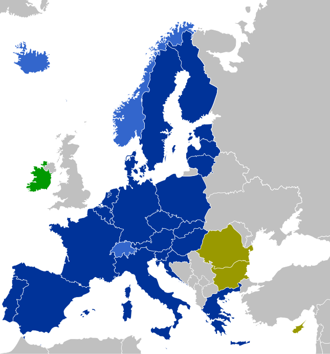
| Description |
Countries which have implemented the Schengen Agreement Dark Blue: EU member states
Light Blue: Non-EU member states
Purple: EU member states with consequent controls on their land borders (planned to be dropped later)
Olive: EU member states which have not implemented the Schengen Agreement yet (without opt-out)
Green: EU member states which apply only some Schengen laws (with opt-out) |
| Date | |
| Source | Own work |
| Author | CrazyPhunk |
| Other versions | There is similar map Schengen Area participation.svg existing. |
| SVG development |
Licensing[edit]
| I, the copyright holder of this work, release this work into the public domain. This applies worldwide. In some countries this may not be legally possible; if so: I grant anyone the right to use this work for any purpose, without any conditions, unless such conditions are required by law. |
File history
Click on a date/time to view the file as it appeared at that time.
| Date/Time | Thumbnail | Dimensions | User | Comment | |
|---|---|---|---|---|---|
| current | 19:51, 31 May 2024 | | 645 × 690 (357 KB) | Stefan040780 (talk | contribs) | Update BG + RO, colours fixed, Malta with circle |
| 13:01, 2 January 2023 |  | 645 × 690 (358 KB) | Iktsokh (talk | contribs) | Correction of borders | |
| 00:43, 1 January 2023 |  | 645 × 690 (478 KB) | Kamran.nef (talk | contribs) | Added Croatia | |
| 19:22, 9 June 2021 |  | 645 × 690 (477 KB) | Geo.smart (talk | contribs) | Reverted to version as of 13:12, 1 January 2021 (UTC) UK is a part of neither EU nor the Schengenzone | |
| 18:26, 2 January 2021 |  | 645 × 690 (477 KB) | Opihuck (talk | contribs) | Reverted to version as of 23:02, 4 February 2020 (UTC) | |
| 13:12, 1 January 2021 |  | 645 × 690 (477 KB) | Ärrännä (talk | contribs) | Reverted to version as of 01:32, 1 February 2020 (UTC) because now United Kingdom is not anymore part of EU | |
| 23:02, 4 February 2020 |  | 645 × 690 (477 KB) | Opihuck (talk | contribs) | Reverted to version as of 21:43, 20 February 2017 (UTC) - GB und IRL continue to be associated at least until end of 2020 | |
| 01:32, 1 February 2020 |  | 645 × 690 (477 KB) | Tohaomg (talk | contribs) | Brexit | |
| 21:43, 20 February 2017 |  | 645 × 690 (477 KB) | Nablicus (talk | contribs) | lakes removed | |
| 12:23, 21 August 2015 |  | 645 × 690 (526 KB) | DaB. (talk | contribs) | Lakes, no Boarders. |
You cannot overwrite this file.
File usage on Commons
The following 10 pages use this file:
- Atlas of the European Union
- User:Chumwa/Gallery
- User:Zinneke/Nei Biller iwwer Lëtzebuerg/2017 February 19-28
- User:Zinneke/Nei Biller iwwer Lëtzebuerg/2020 February 1-9
- User:Zinneke/Nei Biller iwwer Lëtzebuerg/2021 January 1-10
- User talk:Iktsokh
- User talk:Nablicus/Archive 1
- File:Schengen.jpg
- File:Schengenzone.png
- Category:Internal Schengen borders
File usage on other wikis
The following other wikis use this file:
- Usage on af.wikipedia.org
- Usage on als.wikipedia.org
- Usage on ar.wikipedia.org
- Usage on arz.wikipedia.org
- Usage on bg.wikipedia.org
- Usage on bn.wikipedia.org
- Usage on ca.wikipedia.org
- Usage on cs.wikipedia.org
- Usage on de.wikipedia.org
- Schengener Abkommen
- Schengener Informationssystem
- Dezember 2008
- Dezember 2011
- Wikipedia:Kartenwerkstatt/Archiv/2011-05
- Verordnung (EG) Nr. 539/2001 (EU-Visum-Verordnung)
- Verordnung (EU) 2016/399 (Schengener Grenzkodex)
- Diskussion:Flüchtlingskrise in Europa 2015/2016/Archiv/2
- Verordnung (EG) Nr. 810/2009 (Visakodex)
- Benutzer:Tmid
- Portal:Migration und Integration/Artikel des Monats
- Einreise-/Ausreisesystem
- Europäisches Reiseinformations- und ‑genehmigungssystem
- Benutzer:Opihuck/Verordnung (EG) Nr. 539/2001 (EU-Visum-Verordnung)
- Extrempunkte der Europäischen Union
- Benutzer:Kpfiwa/Spielwiese/Test
- Benutzer:Valo139
- Benutzer:Wandelndes Lexikon/alt
- Benutzer:Wandelndes Lexikon/Babel
- Benutzer:Wandelndes Lexikon/Babel/Schengen-Raum
- Benutzer:Wandelndes Lexikon/Babel-Block/Herkunft
- Benutzer:Wandelndes Lexikon/Babel-Block
- Benutzer:Wandelndes Lexikon
- Usage on de.wikibooks.org
- Usage on de.wikinews.org
- Usage on en.wikipedia.org
- Usage on en.wikibooks.org
- Usage on en.wikinews.org
- Usage on es.wikipedia.org
- Usage on eu.wikipedia.org
- Usage on fi.wikipedia.org
- Usage on fr.wikipedia.org
View more global usage of this file.